Stuff a GPS
in your Nexio
..... and head into them hills.

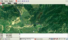
Southern California with a large satelite image loaded from www.terraserver.com

Zoomed in on the same image showing Warner Springs CA
and more importantly Sky Sailing glider airport.
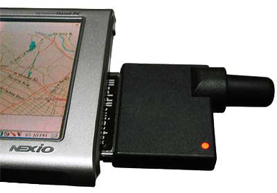
I can not help it, I am a sucker for techie toys, and ever since i got my Samsung Nexio 160 I have been wanting to get one of those GPS cards. After much research and fetting about the price I finally did commit and ordered a TeleType GPS CF-Card and Software. At first I was consused investigating all the options and particularly the two diferent CF cards which Teletype offers, after reading the fine print it turned out that only one were compatible with the GPS signals offered outside the United States, so since my family live in Denmark, and I frequently travle to Asia, it turned out to be a easy choice, the "Recreational World Navigator" is the one for me.
The Recreational CF-Card
is offered in a bundle, with the unit and one of 3 major world areas
in a bundle for $ 170 that is a hard to beat deal. This includes, the
CF-Card, the United States map set, including yellowpages, and highways
of the US, and finally the world-explore GPS software, which installs
both to your PC and to your Pocket PC or WinCE.NET device such as my
Nexio.

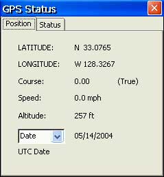
The GPS status panel will
show how many satelites you can see at any time, and it will show you
the actual numerical position for reconding or Geo-Caching if you are
into sports like that.
NOTE.. The software package
was updated in the beginning of May 2005, the software now have birds-eye
view moving map and more avaition features. Along with a lot of other
improvements, You need to ask for your GPS+software bundle to specifically
include the WinCE package, ask for the HPC2000 installer, this is the
one shown in these pictures.
The box arrived and everything
were carefully bobblewrapped, I figured that to be a good start, within
minutes the software were installing on my Fujitsu P5000 laptop, part
of the installer gave me the option to install the WinCE and/or the
Pocket PC package, it was painless, it was just that easy, next time
I connected my Nexio the software were automatically installed, only
problem, the installer did not automatically make a shortcut on the
desktop... But in the world of software problems, that is hardly anything
to loose sleep over.

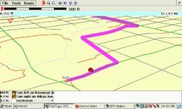
Using Birds eye view to render
a route on the moving map while driving, the GPS will call out your
turns.
Naturally I did not stop to marvel at the PC software first, so I was a bit confused over where to find the maps. As it turns out there is a process to everything. It start on the PC, in the desktop app, open the area you want maps for, then load the maps. Then select "transfer" to bring them into your pocket computer which should be connected to the computer while you do this. Remember there is only limited storage space in the Nexio, so you want to be picky with what you stuff in there. Once transfered to the Nexio, select File - Load - Load Maps and navigate to the maps you are interested in. For now I loaded the street maps of Greater Los Angeles and love using them.
More to the point, the Recreational
unit while maybe not as accurate as its big brother still place me on
the right side of the street when walking home. It takes about 1 minute
to get a good lock on the position, after that things are easy. You
can create a trip by entering a from and to address. then press go to.
Once the sofware is done computing, it presents you with prompts guiding
you to your goal. I like the voice prompts, when getting a ride with
a friend am just as happy to look at the moving map and personally call
out each turn... The Nexio gets high marks for being the coolest GPS
device anyone have seen so far.
IMAGE Maps.
The TeleType software for the Nexio (or any other PPC or WinCE.NET device)
permits you to use a image file as a map, the simplest way is to download
a image file from Microsoft's TerraServer
and use the map info data to create a condinate file for the image,
unfortunately this requires a BMP file. However you COULD purchase the
TeleType GeoCoder software, which will let you incode the same information
into the file info of a JPEG image, the advantage is that you can use
almost any map image, and unlike the BMP it takes up very little space
in your portable computer.
TeleType GPS Card and Software for the Nexio
Bo's
Nexio Page
Bo's
Panorama Page
Bo's
THAI in LA Page (The QUICK way to find a great Thai Restaurant)
|
|